The most seismic zone, encompassing areas with the highest risk of earthquakes. Includes parts of the Northeast, Kashmir, Himachal Pradesh, Uttarakhand, Gujarat, and Andaman & Nicobar Islands.
Published: June 25, 2026, 12:16 PM IST
Share Article
https://www.india.com/news/india/earthquake-in-india-venezuela-tremors-caracas-jammu-kashmir-himachal-pradesh-uttarakhand-bihar-west-bengal-richter-scale-gujarat-kutch-8456714/
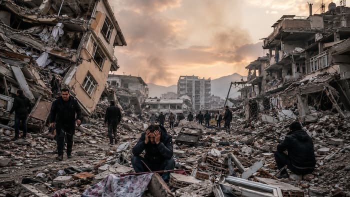
New Delhi: In an unfortunate incident, two powerful earthquakes hit Venezuela on Wednesday evening (local time), killing at least 32 people and injuring about 700 others. The strong tremors damaged buildings and prompted acting president Delcy Rodriguez to declare a state of emergency. According to the reports, the first earthquake had a magnitude of 7.2, and its epicenter was west of the community of Moron, about 168 kilometers west of the capital, Caracas. The quake had a depth of 22 kilometers. The second earthquake struck just a minute later, with a 7.5-magnitude. It had a depth of 10 kilometers, and its epicenter was 16 kilometers southwest of Moron.
The United States Geological Survey (USGS) has said that “high casualties and extensive damage are probable” and the disaster is likely widespread, initially estimating the death count would most likely range from 10,000 to 1,00,000.
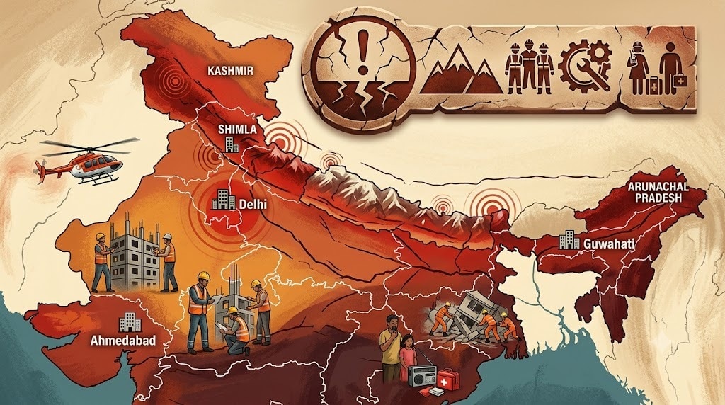
How vulnerable is India to earthquakes?
India is highly vulnerable to earthquakes. It is because of India’s unique geological setting, as it lies in a seismically active region influenced by the northward movement of the Indian plate colliding with the Eurasian plate.
According to the National Disaster Management Authority (NDMA), approximately 59 percent of India’s land area is prone to earthquakes of moderate to high intensity. Understanding the earthquake-prone zones and implementing effective management strategies are crucial for minimizing the impact of these disasters.
The recent earthquake in Turkey and Syria (February 2023) underscores the urgent need for robust earthquake preparedness and mitigation measures.
Regions most vulnerable to earthquakes
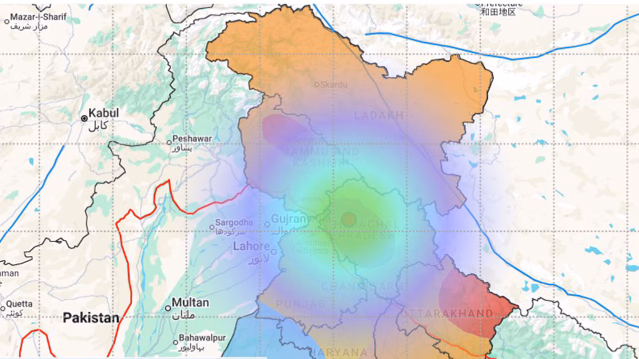
The Himalayan belt—highest risk
The most vulnerable region stretches across the Himalayas, including:
- Jammu and Kashmir
- Himachal Pradesh
- Uttarakhand
- Parts of Bihar and West Bengal
It is important to note that these areas lie directly along the active collision zone between tectonic plates and are considered capable of generating very large earthquakes. Recent revisions to India’s seismic mapping have placed much of the Himalayan arc in the highest risk category.
Other than these states, the entire Northeast region is extremely active seismically. The region has experienced some of the strongest earthquakes in Indian history and remains under constant tectonic stress.
Kutch region of Gujarat
The Kutch region also remains highly vulnerable despite being far from the Himalayas. The devastating 2001 earthquake demonstrated the area’s risk, and recent studies show fresh activity on multiple fault lines.
Earthquake-Prone Zones of India
India is divided into four zones by the Bureau of Indian Standards (BIS) based on the seismic intensity:
Zone V: The most seismic zone, encompassing areas with the highest risk of earthquakes. Includes parts of the Northeast, Kashmir, Himachal Pradesh, Uttarakhand, Gujarat, and Andaman & Nicobar Islands.
Zone IV: High damage risk zone. Includes states like Delhi, Sikkim, Jammu & Kashmir, Punjab, Rajasthan, and parts of Maharashtra.
Zone III: Moderate damage risk zone. Includes states like Kerala, Goa, Tamil Nadu, Madhya Pradesh, and parts of Uttar Pradesh.
Zone II: Low damage risk zone. Includes areas with relatively low seismic activity.
Strategy for Earthquake Management
Pre-Disaster Planning & Mitigation
- Implementing earthquake-resistant building codes and ensuring strict adherence to them.
- Retrofitting existing vulnerable structures (schools, hospitals, public buildings).
- Encouraging use of ductile detailing in construction.
- Non-Structural Mitigation:
- Securing furniture and equipment, preventing falling hazards, and ensuring safe evacuation routes.
- Deploying earthquake early warning systems (EEW) to provide crucial seconds of warning before strong shaking arrives.
- Regular earthquake drills, increased awareness of earthquake safety measures, and training local communities in search and rescue operations.
Disaster Response
Soon after the disaster, rapid damage assessment needs to be carried out by deploying trained teams to quickly evaluate the extent of destruction and identify areas that require immediate assistance. Authorities must then launch search and rescue operations, with the National Disaster Response Force (NDRF) and state-level rescue teams mobilized to locate and rescue trapped individuals.
Medical assistance needs to be provided on priority, including immediate treatment for the injured, setting up field hospitals, and ensuring the availability of medicines and essential medical equipment. More focus must be then given to the relief efforts on shelter and basic necessities, with temporary accommodation, food, clean water, and other essential supplies provided to affected populations.
At the same time, effective communication and coordination are established among government agencies, NGOs, and local communities to ensure a well-organized and efficient disaster response.
Post-Disaster Rehabilitation & Reconstruction
A comprehensive assessment of the damage must be conducted to identify the needs of affected communities.
Rebuilding damaged infrastructure (roads, bridges, schools, hospitals) to restore essential services.
Providing financial assistance and livelihood support to affected communities to help them rebuild their lives.
Providing psychological counseling and support to help affected individuals cope with the trauma of the earthquake.