Delhi and Mumbai continue to grapple with heavy monsoon showers, disrupting normal life and causing waterlogging in several areas. Here’s the latest IMD weather update and rainfall forecast for Delhi-NCR and other parts of India.
Published: July 9, 2026, 8:28 AM IST
Share Article
https://www.india.com/news/india/imd-weather-update-delhi-orange-alert-mumbai-monsoon-havoc-heavy-rain-isolated-heavy-rain-likely-over-madhya-pradesh-chhattisgarh-rajasthan-check-delhi-ncr-weather-forecast-rain-alert-8469190/

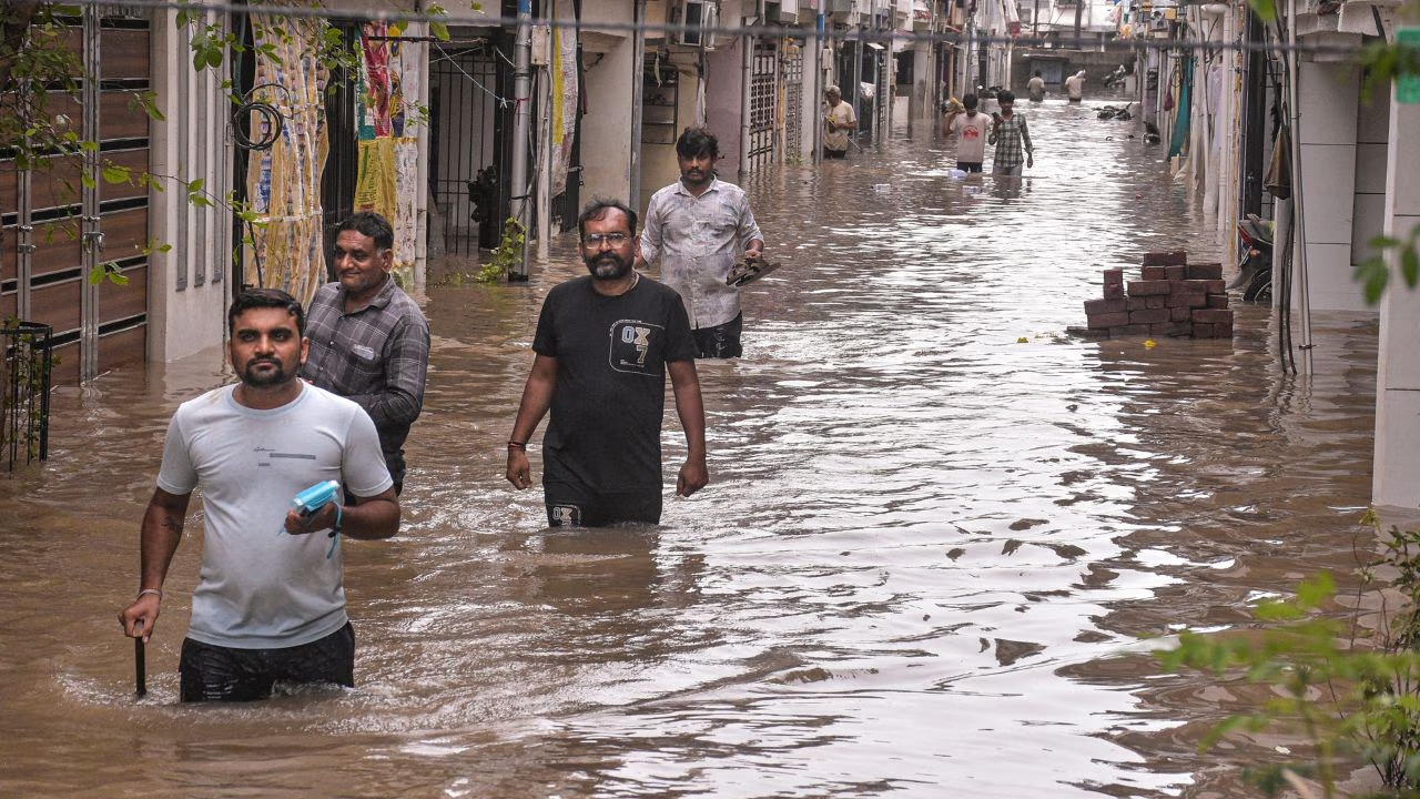
Surat: Pedestrians make their way through a severely waterlogged road following heavy rainfall, in Surat, Gujarat, Wednesday, July 8, 2026. (Photo Credit: PTI)
IMD weather update: Several parts of Delhi received heavy rain in the early hours of Thursday, extending a wet spell in the national capital and bringing much-needed relief to residents from the recent humid conditions. However, the heavy rain also caused waterlogging in several areas, including Munirka. The India Meteorological Department (IMD) has issued an “Orange Alert” for the capital, signalling heavy rainfall over the region through most of the day. Several parts of India are receiving heavy rainfall, with Mumbai among the worst-affected cities.
Which states are likely to receive heavy rainfall over the next few days?
The IMD has forecast a generally cloudy sky over Delhi-NCR, with very light to light rain at many places and moderate rainfall at isolated locations accompanied by thunderstorms, lightning, and strong winds of 30-40 kmph, gusting up to 50 kmph, during the morning and forenoon. Another spell of light rain is expected across many areas, with moderate showers at isolated places, during the afternoon and evening. The maximum and minimum temperatures over Delhi are likely to be in the range of 32°C to 34°C and 23°C to 25°C, respectively. The minimum temperature will be appreciably below normal (-3.1°C to -5.0°C) at most places, and the maximum temperatures will be below normal (-1.6°C to -3.0°C) at most places over Delhi. “The predominant surface wind is likely to be from east direction with surface wind speed reaching up to 25 kmph during the morning hours. The wind speed will decrease becoming up to 18 kmph from the east direction during the afternoon. The wind speed will increase becoming up to 20 kmph from the southeast direction during evening and night,” the weather department stated.
According to the India Meteorological Department(IMD) press release, fairly widespread to widespread rainfall is likely over Andaman & Nicobar Islands from July 8 to 11 and again on July 14. Similar conditions are expected over Sub-Himalayan West Bengal and Sikkim from July 8 to 14, Gangetic West Bengal from July 10 to 14, Jharkhand on July 9-10 and July 12-14, and Bihar on July 8 and July 10-11.
Will Madhya Pradesh, Chhattisgarh and Rajasthan witness isolated heavy rainfall?
Fairly widespread to widespread rainfall is likely over Jammu-Kashmir-Ladakh-Gilgit-Baltistan-Muzaffarabad during July 8-12, and over Himachal Pradesh and Uttarakhand during July 8-14. Fairly widespread to widespread rainfall is also likely over Punjab on July 9; Haryana, Chandigarh and Delhi, and West Uttar Pradesh during July 8-10; East Uttar Pradesh during July 8-13; and East Rajasthan during July 8-9.
Isolated heavy rainfall is likely over Jammu-Kashmir-Ladakh-Gilgit-Baltistan-Muzaffarabad on July 8 and during
July 11 and 12; Himachal Pradesh between July 8 to July 14; Uttarakhand during July 8-9 and during July 11-14
July; Haryana Chandigarh & Delhi and Punjab during July 8-12 July; West Uttar Pradesh during July 10-July 11; East Uttar Pradesh during July 809nJuly and on July 13; West Rajasthan on July 8; East Rajasthan on July 10 with
isolated very heavy rainfall also likely over Uttarakhand on July 10; East Rajasthan and West Uttar Pradesh
during July 8-9; East Uttar Pradesh during July 10-12.
According to the weather agency, Isolated heavy rainfall is likely over West Madhya Pradesh on July 8 and July 10; East Madhya Pradesh during July 11-12; Vidarbha during July 13-14; and Chhattisgarh during July 12-14. Isolated very heavy rainfall is also likely over West Madhya Pradesh on July 9 and East Madhya Pradesh during July 8-10.
Isolated thunderstorms accompanied by lightning and gusty winds of 40-50 kmph, gusting up to 60 kmph, are likely over Andaman & Nicobar Islands during July 10-14, Gangetic West Bengal on July 9, and Jharkhand during July 8-12.
Meanwhile, gusty winds of 30-40 kmph, gusting up to 50 kmph, are likely over Andaman & Nicobar Islands during July 8-9, Gangetic West Bengal on July 8 and during July 10-14, Bihar on July 8 and during July 10-12, and Odisha during July 8-12.
“Fairly Widespread to Widespread rainfall likely over Punjab on 9th July; Haryana Chandigarh & Delhi and West
Uttar Pradesh during 8th-10th July; East Uttar Pradesh during 8th-13th July; East Rajasthan during 8th-9th July,” IMD stated. Several parts of Maharashtra continued to grapple with the monsoon fury as rivers swelled up, train services were disrupted, and landslides and waterlogging incidents threatened people’s safety. Surat in Gujarat received torrential rains, with officials saying at least nine people have died in rain-related incidents in the last few days in the district, news agency PTI reported.
IMD Weather forecast for Delhi-NCR
- July 9: Generally cloudy sky. A spell of very light to light rain at many places with moderate rain at isolated places accompanied with thunderstorm/lightning/strong winds speed reaching 30-40 kmph gusting to 50 kmph towards morning/forenoon. Another spell of very light to light rain at many places with moderate rain at isolated places towards afternoon/evening. The maximum and minimum temperatures over Delhi are likely to be in the range of 32°C to 34°C and 23°C to 25°C, respectively. The minimum temperature will be appreciably below normal (-3.1°C to -5.0°C) at most places, and the maximum temperatures will be below normal (-1.6°C to -3.0°C) at most places over Delhi. The weather agency said, “The predominant surface wind is likely to be from east direction with surface wind speed reaching up to 25 kmph during the morning hours. The wind speed will decrease becoming up to 18 kmph from the east direction during the afternoon. The wind speed will increase becoming up to 20 kmph from the southeast direction during evening and night.”
- July 10: Generally cloudy sky. Possibility of very light to light rain/thunderstorm/lightning towards morning/forenoon. The maximum and minimum temperatures over Delhi are likely to be in the range of 34°C to 36°C and 24°C to 26°C, respectively. The minimum temperature will be below normal (-1.6°C to -3.0°C) at most places, and the maximum temperatures will be near normal (-1.5°C to 1.5°C) at most places over Delhi. The predominant surface wind is likely to be from east direction with surface wind speed reaching up to 10 kmph during the morning hours. IMD stated, “The wind speed will increase becoming up to 18 kmph from the east direction during the afternoon. The wind speed will decrease becoming up to 15 kmph from the southwest direction during evening and night.”
- July 11: Generally cloudy sky. Possibility of very light to light rain/thunderstorm/lightning towards
forenoon/afternoon. The maximum and minimum temperatures over Delhi are likely to be in the range of 36°C to 38°C and 25°C to 27°C, respectively. The minimum temperature will be near normal (-1.5°C to 1.5°C) at many places with below normal (-1.6°C to -3.0°C) at isolated places, and maximum temperatures will be near normal (-1.5°C to 1.5°C) at many places with above normal (1.6°C to 3.0°C) at isolated places over Delhi. The predominant surface wind is likely to be from the southwest direction with wind reaching up to 14 kmph during the morning hours. The surface wind speed will increase becoming up to 16 kmph from the southwest direction during the afternoon. The wind speed will increase becoming up to 20 kmph from the west direction during evening and night.