The India Meteorological Department reports a worrying 40% national rainfall deficit as the crucial southwest monsoon stagnates, leaving core agricultural states completely devoid of cloud cover.
Share Article
https://www.india.com/news/india/monsoon-tracker-june-17-bad-news-for-india-as-clouds-remain-absent-heres-how-rain-winds-are-moving-8449170/
Monsoon Update- File image
Monsoon tracker June 17: In a significant update the residents of India eagerly waiting for monsoon rain, the lifeline of India’s agricultural economy is showing worrying signs of distress. As per the update shared by Indian Meteorological Department (IMD), the critical southwest monsoon has hit a severe period of stagnation, leaving a massive 40% nationwide rainfall deficit and triggering early alarms for the upcoming crop season. Here are all the details you need to know about the Monsoon update shared by the IMD.
How is South-West Monsoon impact India?
Fresh satellite imagery captures a stark reality: the country’s core rain-fed agricultural belt is currently laid bare, completely stripped of the dense cloud cover typical for mid-June. As clear skies dominate the central and western plains, the vital weather system has stalled, locking away needed moisture and forcing farmers into an anxious waiting game.
Crucial Monsoon Indicators
-
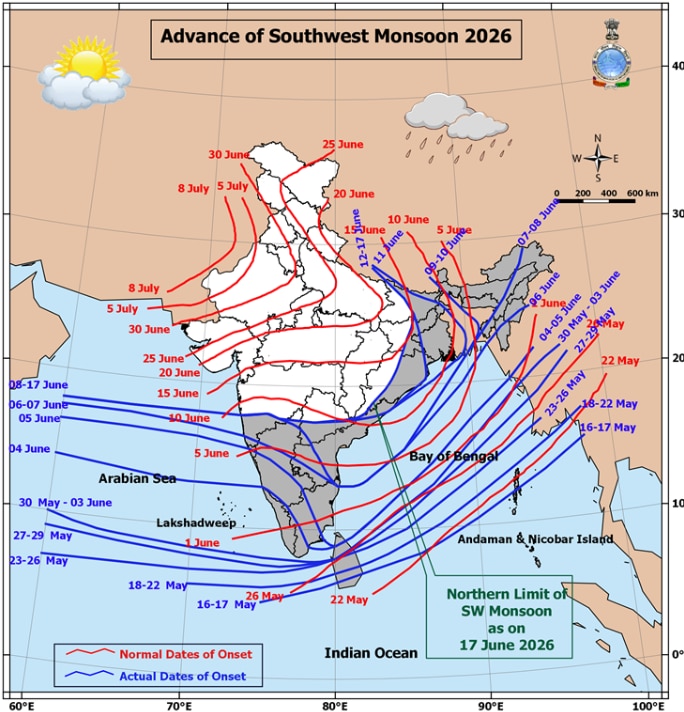
The Bare Map: Morning imagery from the INSAT-3DS satellite on June 17 reveals vast, cloudless zones over Maharashtra, Gujarat, Madhya Pradesh, Rajasthan, and interior Karnataka, signaling a near-total collapse of active monsoon progression in these areas.
-
Displaced Storms: Instead of spanning across the Indian peninsula, organized cloud bands and heavy rain systems are heavily confined to the Bay of Bengal, Northeast India, and the equatorial Indian Ocean.
-
The 40% Rain Gap: Between June 4 and June 17, India recorded just 39.7 mm of rainfall against the long-period average of 65.9 mm, solidifying a steep 40% national deficit, according to the India Meteorological Department (IMD).
Weak monsoon to impact to impact summer heat in West Bengal
A weak monsoon is likely to extend the summer woes of south Bengal despite it advancing into the region last week, with the weather department forecasting sweltering heat in this part of the state over the next week.
The India Meteorological Department (IMD) on Tuesday said the southwest monsoon is active in the sub-Himalayan districts of West Bengal and will bring heavy rain there over the next week.
In the southern part of the state, isolated regions may witness light rainfall till June 19 and widespread showers on June 20 and 21. In view of the weather conditions, the government changed the timings of all state-run and aided schools to morning hours so that students need not venture out in the oppressive heat.
El Nino impact: Agriculture Minister calls for advance contingency planning in rain-deficient districts
As the El Nino threat looms, Union Agriculture Minister Shivraj Singh Chouhan on Tuesday stressed the need for advance contingency planning in rain-deficient districts, while also pushing for increased acreage under cotton and pulses. In a high-level weekly agriculture review meeting with senior officials held at Krishi Bhawan here, a detailed review was conducted of the nationwide preparations for Kharif 2026.
(With inputs from agencies)